Limestone County Heritage Symposium 2018
Early Pottery Kilns of Limestone County
On April 21, 2018, the Limestone Historical Commission hosted a symposium, which featured a presentation on late nineteenth-century pottery kilns that were located in Limestone County and a workshop to assist individuals with completing First Families of Limestone County applications.
David Sherman, Meg Cruse, and Andrea Burden, archeologists with Blanton & Associates of Austin, gave a most interesting presentation on the Lee Kimk Kiln and the 41LT441 site, which are located within the Kosse Mine.
The Kimik Kiln site received state recognition with an official Texas Historical Marker authorized by the Texas historical Commission in 2014. Arceological excavations at 41LT441 began in 2017 and have resulted in a recommendation that the site is eligible for the National Register of Historic Places. Both sites feature ground-hog style pottery kilns and hundreds of artifacts including a wide variety of stoneware vessel forms and glazes suggesting experimentation in the use of local ingrdients, responses to market demand, or both. Although many of these wares were likely sold locally, access to nearby railroad hubs could have distributed the wares as far as Austin or Dallas.
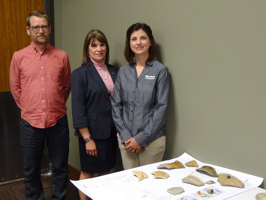 Presenters David Sherman, Meg Cruse, and Andrea Burden
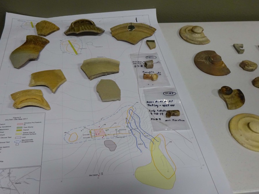 Pottery sherds from the Kimik Kiln and 41LT441 sites.
 Linda Jordan gives advice for completing a First Families of Limestone County application
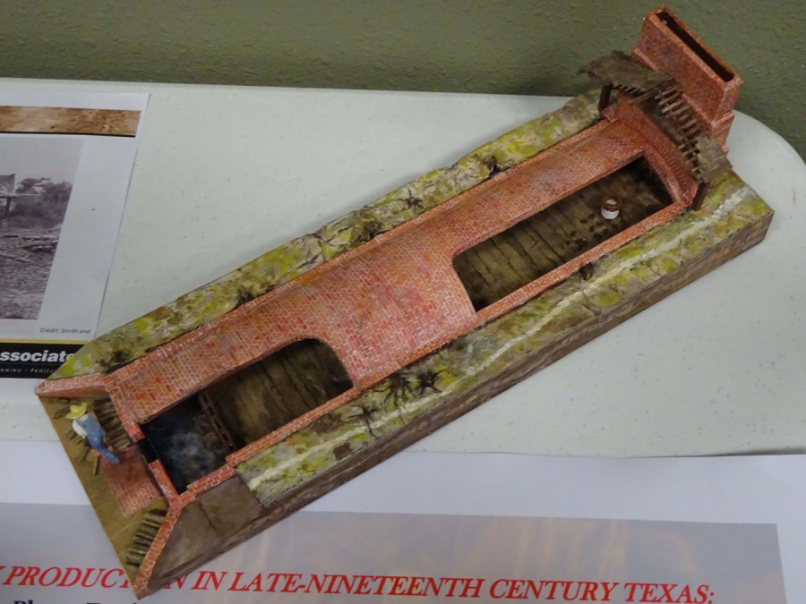 Model of a ground-hog style pottery kiln
Archeological Documentation at 41LT198 Kimik Kiln and
National Register of Historic Places Eligibility Testing at 41LT441, Limestone County, Texas
By Andrea Stahman Burden, Meg Cruse, and David Sherman
Senior Archeologists
Blanton & Associates, Inc., Austin, Texas
Presented at the Limestone County Heritage Symposium
April 21, 2018 in Groesbeck, Texas
Abstract
Luminant has been involved in cultural resources management for more than 30 years. During this time more than 200 prehistoric and historic archeological sites have been recorded at the Kosse Mine. These historical and archeological investigations have provided insight into the utilization of local natural resources and how this utilization has driven economic development and settlement patterns including migration patterns of first families into the county. Beginning in 2006, Kosse Mine investigations identified a handful of late-nineteenth century potteries, among these were two historically significant sites: 41LT198, known as the Lee Kimik Kiln, and site 41LT441.
Nationally, small-scale folk or traditional stoneware potteries, colloquially known as jug factories, played a significant role in the culture and economy of nineteenth-century America. Producing jugs, jars, churns, bowls, and pitchers, such factories provided seasonal income to folks that for much of the year derived a livelihood from the land, operating farms and ranches. Originating in South Carolina, commercial stoneware production expanded into new markets with early nineteenth-century westward migration, and among those areas with suitable clay resources was Texas.
This presentation examines the archeological remains of Kosse Mine’s most well-known potteries, Kimik Kiln and site 41LT441. The Kimik Kiln site received state recognition with an official Texas Historical Marker authorized by the Texas Historical Commission in 2014. Archeological excavations at 41LT441 began in 2017, and have resulted in a recommendation that the site is eligible for the National Register of Historic Places. Both sites feature ground-hog style pottery kilns and hundreds of artifacts including a wide variety of stoneware vessel forms and glazes suggesting experimentation in the use of local ingredients, response to market demand, or both. Although many of these wares were likely sold locally, access to nearby railroad hubs could have distributed the wares as far as Austin or Dallas.
SLIDE 1: Nineteenth-Century Folk Stoneware Potteries
Introductions by Meg Cruse
Andrea Stahman Burden – historic archeologist with about 20-years of experience as professional archeologist and has been involved in many Luminant projects.
David Sherman – has been involved with Luminant archeology since 1996 and has been involved in almost all of the survey, testing, and mitigation projects on the mines.
Archeology
Luminant, through its commitment to cultural resources, has provided the State of Texas, the local community, and the archeological community with a rare look into the prehistory and history of Texas. For more than 30 years, Luminant has actively contributed to the knowledge of Texas’s rich history through the sponsorship of archeological investigations across nine East Texas counties. More than 1,200 prehistoric and historic archeological sites have been recorded through their efforts. Archeological investigations consist of historic records research, field surveys to locate archeological sites, and excavations to determine the potential of a site for contributing important scientific and historical information.
WHY We Do Archeology
The story of Historic Texas begins with the first French and Spanish explorers and continues into the present. Because of Texas’s many periods of occupation by different countries (Spain, France, Mexico, and the United States), the types and varieties of historic artifacts found are as diverse as the people themselves. Some of the objects that are found on historic sites include rifle and shotgun casings, nails, bottle caps, glass, plastic, barbed wire, fence staples, tableware, tin cans, newspaper fragments, doorknobs, buttons, and more. The type of glass, style of nail, or newspaper fragments, for instance, may suggest a period of occupation for a historic property. Additionally, the artifact can also give clues about the peoples’ activities. Barbed wire could indicate a fence location where one no longer exists, possibly suggesting some type of ranching. The type and quantity of bottles may point to whether someone suffered an extended illness or whether there was a saloon located on the property. The type of dishware may give investigators corroboration of the change in wealth from one generation to another.
Archeological investigations at Luminant mine sites such as the 41LT198, the Kimik Kiln and 41LT441 have added a wealth of information to our understanding of the lifeways of early Texas settlers as well as providing a window to life in early to late-nineteenth-century East Texas and expanding our understanding of some of the early settlements on the Texas frontier
SLIDE 2-The Video
See Video at this link: https://www.youtube.com/watch?v=x_5-vvFOdvs
TRADITIONAL STONEWARE POTTERIES IN AMERICA
(SLIDE 3-What is Stoneware?)
What is stoneware? Stoneware is a type of ceramic composed of a light-colored refractory clay fired at a high enough temperature, usually between about 2,300 and 2,500 degrees Fahrenheit (1,200-1,350 degrees Celsius), to vitrify the paste so that it becomes waterproof. It can be glazed with a clay slip, salt glazed, or alkaline glazed. Alkaline-glazed stoneware was first produced in America by Dr. Abner Landrum around 1810 at Pottersville (38ED011) in the Edgefield District of South Carolina (Calfas 2013; Koverman 2007) (SLIDE 4- MAP OF SOUTHERN US, click for Edgefield arrow) where the workforce included enslaved African American laborers, both unskilled and skilled (e.g., Dave the Potter AKA Dave Drake) (Calfas 2013) (SLIDE 5- Dave the Potter Pots).
Pottersville wares were “an array of utilitarian vessels” (Calfas 2013:5), i.e., jugs, jars, crocks, pitchers, etc. covered with an alkaline glaze that is harder and more durable than clay slip and less expensive than salt glaze, and is comprised of locally available wood ash, clay, and sand, where the ash acts as a flux. The variations of color and texture of the alkaline glaze varies tremendously according to variations in local ingredients and the potter’s preference. Often a greenish glaze that easily agglutinates or sticks together in a mass, alkaline glaze can vary from straw yellow to celadon green, reddish brown or dark brown depending on placement of the vessel within the kiln, wood variety of the fuel, or composition of the clay (Brown 2015:56; Greer 1981:204, 207).
Alkaline-glazed stoneware pottery production spread westward with immigration between 1820 and 1850 (SLIDE 6- MIGRATION MAP IN SOUTHERN US). Research indicates that during this period many potters migrated from South Carolina though Georgia, Alabama, and Mississippi to Louisiana and on to Texas (Koverman 2009:125)[1] and following suitable clay resources, particularly kaolin clay, which often coincides with lignite coal deposits (Pence 1954; Ries 1903, 1908; Ries and Bayley 1922) (SLIDE 7- Geology MAP Kaolin deposits IN SOUTHERN US) (SLIDE 8- Clay Mining with mules and dump carts). Among them were members of Abner Landrum’s extended family including Reuben Drake[2], Jasper Gibbs[3], and Jefferson Nash (Koverman 2009:129-130) (SLIDE 9- Works of Edgefield Potters in Texas).
Although many of these kilns operated year-round as industrial enterprises, many more times their number were operated on a seasonal basis. Differences between the two operations often also included kiln design as seasonal, folk, or small-scale operations often employed groundhog-style kilns, while many large-scale operations built beehive-style kilns. Groundhog kilns were so named because they were rectangular, low-walled, and built into the side of a slope much like a burrowing animal (Greer 1977a; Kurlander 2015:4; Smith and Rogers 2011:25)
(SLIDE 10- Groundhog Kiln example).
(SLIDE 11- Photo of Groundhog Kiln in operation).
TEXAS STONEWARE POTTERIES AND ARCHEOLOGICAL RESEARCH
(SLIDE 12-Map of Texas Potteries)
Thanks to the work of Georgeanna Greer and James Malone, and others, upwards of 100 stoneware potteries are known in 24 Texas counties (Atlas 2018; Greer 1979; Helberg 2000; R. L. Polk & Co. 1882, 1890). Several of the proprietors of these sites have connections back to South Carolina, e.g., Alberry Johnson at 41LT122, with some directly associated with Abner Landrum and the Edgefield District, e.g., James Kirbee at 41MQ38, John Leopard at 41RK57, and James Prothro at 41RK63 (Koverman 2009:124), and Jefferson Nash (Marion/Cass County-no trinomial). Of these, 46 have been formally recorded as archeological sites and only about five (not including 41LT441) have been subjected to archeological excavation (Atlas 2018; Brackner 1981; Brown 2015:55; Greer 1977b; Hunger 2003; Kinz and Morgan 2009; Komes 2015).[4]
The Limestone County Pottery Industry
(SLIDE 13- Map of Limestone County Potteries)\
Small-scale and industrial stoneware potteries operated in Limestone County during the nineteenth century and into the early twentieth century at communities such as Kosse, Headsville, Pottersville (later known as Oletha), and Dooley Creek (later known as Old Union) (Dixon and Sherman 2010:26; Sherman and Watkins 2007:85). [5] [6] Seven of these pottery kilns have been archeologically documented, including the Alberry Johnson Pottery (41LT122), the Curtis Knox/John Fowler Pottery (41LT11), the Lee Kimik Pottery (41LT198), Kosse Fire Brick and Tile Co. (41LT123), White-Stone Pottery (41LT197), site 41LT405, and site 41LT441.
(SLIDES 14-18 Examples of Pots)
Archeological Investigations at 41LT198, the Kimik Kiln
(SLIDES 19-33)
The kiln was owned and operated by Lee Kimik from Wertenberg, Germany, roughly during the period between 1875 and 1883. The kiln was known locally as the Kimik Kiln. It was a groundhog kiln with deeper and longer side walls than was typical for southern potteries.
The Kimik Kiln was part of a local pottery industry established in the vicinity of high-quality clay deposits, or “potters clay” in Limestone County and centered in the town of Oletha, Texas, which was also known as “Pottersville.” The pottery industry played an important role in the development of the local community.
Four other kiln sites have been recorded in southern Limestone County in the vicinity of the Kosse Mine, including 41LT11 (which operated from the 1850s to around 1910), 41LT122 (which operated from the 1850s to around 1870), 41LT267 (which operated from 1870 to 1910) and site 41LT441
Mr. Kimik produced stoneware and earthenware at his kiln and sold his wares directly to the community of Headsville.
Remnants of the kiln walls, a pile of bricks thought to represent the kiln chimney, and piles of waster sherds have been preserved on site.
The kiln walls were about 2.5 feet thick and covered with vitrified salt, which was used to glaze some of the pottery. Kimik also used a brown slip, very similar to Albany slip glaze, to finish some of his wares.
Kiln “furniture” such as “busicuits” and “setters” were found widely distributed across the site. These objects were used to stack the pottery in the kiln prior to firing.
The site also harbors evidence of a former residence, presumably that of Lee Kimik, though no structural remains of the residence are present on-site.
Archeological Investigations at 41LT441
(SLIDE 34-Map of site location)
Site 41LT441 is located at a strategic location along a stream with access to clay outcrops and timber, also near a major transportation route-road to Thornton, 10 miles from the railhead there and one at Groesbeck. (SLIDES 35-36 Photos of site in 2008) The site was subjected to archeological investigation in 2017 (SLIDEs 37-39 Photos of Site 2017), which entailed archival research, mechanical scraping of approximately 335 square meters (3,607 square feet), mechanical excavation of two trenches, and hand excavation of five 1-x-1-meter units (SLIDE 40 Map of investigations).
During the fieldwork eight cultural features were identified, including the groundhog kiln, and 590 artifacts were collected for further analysis. Here is the groundhog kiln (SLIDE 41-closeup map of kiln). (SLIDES 42-43-photos of kiln feature) Our excavations revealed the kiln’s dimensions were about 42 feet long by 10 feet wide, which is particularly large in comparison to other contemporaneous potteries in other southern states that generally ranged from approximately 16-20 feet in length and 6-8 feet in width (Espenshade 2002:189-190; Greer 1977a)[7].
A variety of stoneware ceramics were recovered from the site (SLIDE 44-all glazes) including clay slip, salt glazed, and a large number of alkaline-glazed sherds. Salt drips were evident on some sherds (SLIDE 45-salt drips). A 2-gallon capacity mark was noted (SLIDE 46-Capacity Mark). Stoneware pipes (SLIDE 47-Pipes). Kiln furniture (SLIDE 48- kiln furniture).
(SLIDE 49-Photo of an old pottershop)
Archival research, although not conclusive, suggests that William Sion “W.S.” Roberts was the owner and operator of the kiln at 41LT441. Indications are that Roberts, who had either operated or had an interest in a previous mercantile at Thornton, bought a 120-acre tract previously owned by Henry H. Stevenson from his widow Hannah around 1890, and constructed the pottery kiln at 41LT441 shortly thereafter (Limestone County District Court Records I:499). By 1893, he was living on a 460-acre farm northwest of 41LT441, and was “one of the most honorable and highly respected citizens of Limestone county (Lewis Publishing Company 1893:732)” (Limestone County, Texas Tax Roll 1887). In 1900, H.H. Stevenson’s heirs sued Roberts and others alleging that Hannah Stevenson had allowed her new husband T.F. Thames and Roberts to acquire the Stevenson homestead property by defaulting on her tax payments (Limestone County District Court Records I:499). Eventually the heirs prevailed in their lawsuit, gaining back title to the homestead including the kiln at 41LT441, for which they paid Roberts $750 (assessed value of the unidentified improvements). The Stevenson heirs no longer maintained an interest in the parcel containing the kiln at site 41LT441 after 1905 (Dixon et al. 2010). Subsequent owners and possible operators of the kiln included Thornton merchant P.K. McKenzie between 1905 and 1922, and Oletha merchant George Barnett in the 1930s, and the site was abandoned by 1966 as structures associated with the site are not evident on an aerial photograph of the area from that year (National Environmental Title Research 2018).
Based on the kiln dimensions, it is possible to speculate on the production potential of the kiln using volumetric calculations of the potential volume of the loading shelf within the kiln. These calculations suggest the structure may have had a maximum capacity of approximately 527 gallons worth of stoneware per firing. If operated only seasonally (e.g., three months/year) with six firings per year (e.g., once every two weeks), the kiln could produce up to 3,162 gallons of stoneware per year. Based on this estimate, at the 1899 average stoneware price of 5 cents/gallon (Middleton 1902:944), we think the pottery at 41LT441 could gross around $158 per year. These wares were likely sold either directly to the public or through retail outlets such as mercantile stores at Oletha, Thornton, Kosse, or Groesbeck, but also may have been sold as far away as Dallas or Austin. It is also clear from the artifact assemblage recovered from the site that the variety of wares produced at 41LT441 and glaze techniques employed were likely dictated by the local or regional utilitarian stoneware market.
In conclusion (SLIDE 50-Photo of clay quarry), mining has been an integral part of the economy in Limestone County since folks were digging into clay banks in the 1850s. (SLIDE 51-Photos of Kimik’s Pots) These clay resources were turned into consumer goods at sites like Kimik Kiln and 41LT441. (SLIDE 52-Luminant Montage) Thanks to Luminant’s sponsorship, research at sites like these continues to illuminate and enrich the history of this area.
SLIDE 53-Thanks
SLIDE 54-Questions?
[1] “Some historians have estimated that between 1820 and 1850, more than half of the South Carolinians and about 25 percent of Georgians migrated to the Old Southwest, that is, to Alabama, Mississippi, and Texas. … Land speculation was one of the main reasons many moved west. … One of the main [wagon roads] that led from Edgefield and Hamburg into Georgia followed a route similar to present-day Interstate 20. The road, which also followed the Fall Line and its related natural resources of good clay and abundant water supply, traversed Georgia through the capitol of Milledgeville, and then crossed Creek Indian Territory into Montgomery, Alabama (Koverman 2009:125).”
[2] In 1836, “Reuben Drake [nephew of Abner Landrum] and his family left Edgefield and moved to [Mount Lebanon, Claiborne Parish (later part of Bienville Parish)], Louisiana along with forty other Edgefield families. This may have been a response to the opening of lands in the West effected by the Indian Removal Act of 1830 and the Trail of Tears, as well as a reaction to the economic depression caused by the Panic of 1837, when many banks closed their doors (Koverman 2009:129).” In 1861, Rueben Drake moved to Hempstead, Austin County (now Waller County), Texas where he resided in 1867 and died during a yellow fever epidemic there in the late summer/fall of that year (Bucher 2013; Spindler nd:12; Ancestry.com-Texas Voter Registration Lists, 1867-1869).
[3] Dr. Jasper Gibbs was born in Union, Union County, South Carolina in 1810 (Ancestry.com-Kristin Simonds Family Tree 2018; Bucher 2013). In 1832, Gibbs entered a partnership in Abner Landrum’s Pottersville manufactory at Edgefield, South Carolina with Reuben Drake, nephew of Abner Landrum, after Drake’s brother and previous partner, Harvey Drake, died (Koverman 2009:127). In 1833, Jasper Gibbs, with his business partner, Rueben Drake, purchased Dave Drake from presumably Harvey Drake’s estate for $400 (Koverman 2009:127). Gibbs married Harvey Drake’s daughter, Laura Jane Drake, in 1839, and moved his family to Panola County, Mississippi in 1843, and then to Claiborne Parish (later part of Bienville Parish), Louisiana in 1844 where he joined Rueben Drake (Ancestry.com-Kristin Simonds Family Tree 2018; Baldwin 1993:38; Bucher 2013; Koverman 2009:130; The Mexia Weekly Herald 1948; The Weekly Union Times 1877). By 1863, Dr. Jasper Gibbs had relocated his family near Cotton Gin in Freestone County, Texas, and finally in 1870 to Mexia in Limestone County, Texas, where he died and was buried in 1877 (Bucher 2013; Hamner 2011; The Mexia Weekly Herald 1948; The Weekly Union Times 1877).
[4] Texas pottery manufacturing sites subjected to any archeological excavation are: Durham-Chandler-Wilson (41GU4-NRHP Listed) (Kinz and Morgan 2009), Guadalupe Pottery aka Wilson First Site (41GU6) (Brackner 1981; Brown 2015:55; Komes 2015), Babcock Pottery Manufactory (41JK160) (Greer 1977b), Kirbee Kiln (41MQ38-NRHP Listed) (Malone et al. 1979), and G. W. Suttles (41WN60) (David Nickels’ 2002 excavations noted in Hunger 2003).
[5] “Headsville and its Clay-mining and Pottery-making Industries-Glander et al. (1984, 1986) have reported that mining of high-quality clay deposits and a regional pottery industry were important to the history of the Headsville Community and local residents as sources of employment, income, and household goods. Furthermore, within the context of other documented pottery-manufacturing operations in northern Robertson County and southern Limestone County, Dr. Georgeanna Greer reports that the Kimik Kiln (41LT198) is unusual for its design and its association with its German builder, Lee Kimik. Can archival historical research provide additional information useful for developing a better understanding of the economic relationship between Headsville and the local mining and ceramic-manufacturing industries? Additionally, can review of deed, tax, and census records provide additional information useful for better understanding the ethnic composition of this community and people employed in the mining and pottery-making industries? Unfortunately, the archival record for Limestone County is incomplete due to a courthouse fire in 1873 that destroyed all early deed, tax, and vital records. This lack of information has created huge gaps in the historical record that have prevented development of an understanding of the early community development of the Headsville area. It has also created difficulty in establishing individual residents’ ethnic backgrounds and economic relationships (Sherman and Watkins 2007:85).”
[6] “Aside from ranching and agriculture, the pottery industry of Limestone County also played a significant role in the economy, both regionally and within the current project area. By the mid-nineteenth century, several small-scale shops thrived in rural communities, and larger commercial kilns developed by the turn of the century. This early industrial development was due in large part to the presence within the county of a number of significant outcroppings of kaolinite, or ‘potter’s clay,’ found within the limits of the Wilcox Formation. The availability of such quantities of clay resulted in the industry’s emergence alongside and in support of the more prevalent agricultural sector (Greer 1984) (Dixon and Sherman 2010:26).”
[7]For comparison, the only other groundhog kiln features for which horizontal dimensions have been archeologically recorded are at Lee Kimik’s Kiln (41LT198), the Durham-Chandler-Wilson Site (41GU4), and Kirbee Kiln (41MQ38). The kiln at the Durham-Chandler-Wilson Site (41GU4) was 26 feet long by 9 feet wide (Kinz and Morgan 2009), that of Lee Kimik (41LT198) was 36 feet long by 8.2 feet wide (Kotter et al. 1988:77), and that 41MQ38 was 39 feet long by 8.8 feet wide (Greer 1977a:47). Note that although Malone et al. 1979:27 describes the Kirbee kiln as over 18 m in length and 4.5 m in width, which would be 59 feet by 14.8 feet, I believe these dimensions are erroneous, resulting from the conversion to metric measurements as it is inconsistent with dimensions of this kiln noted by Greer 1977a:47.